Welcome to the Rudloe and environs website.
Here you will find news, articles and photos of an area that straddles the Cotswold Area of Outstanding Natural Beauty in north-west Wiltshire.
Contributions in the form of articles or photos are welcome. Even those with completely contrary views to mine!
Thanks to the website builder 1&1 and Rob Brown for the original idea.
Rudloescene now, in January 2014, has a sister, academic rather than anarchic, website about Box history here: http://www.boxpeopleandplaces.co.uk/
It contains thoroughly professional, well-researched articles about Box and its people.
Contact rudloescene through the 'Contact' page.
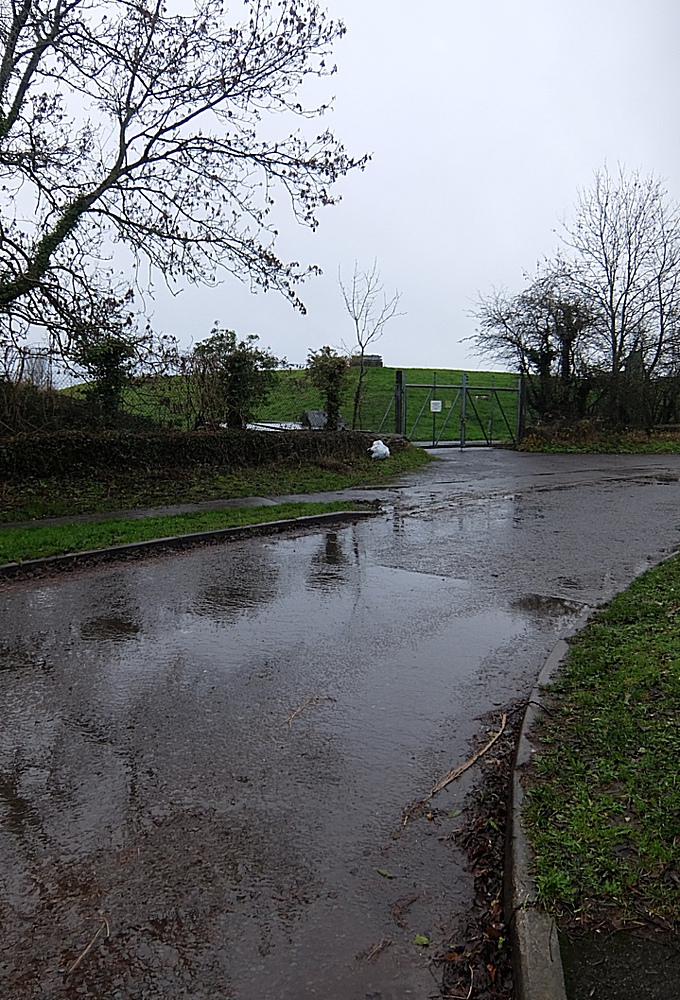
There is a proposed development (19/01507/FUL) from Freeman Brothers for a 438 sq-metre storage building beyond the reservoir (shown above) in Boxfields Road. The Wiltshire Council webpage for the development may be found here Wiltshire Council planning page. A representation to Wiltshire Council planners from yours truly is shown below.
Representation on Planning Application 19/01507/FUL – Erection of agricultural building for storage – Land West of Reservoir, Leafy Lane, Corsham
- The first thing to note is that the site lies at the eastern edge (and inside) the Cotswold Area of Outstanding Natural Beauty and in a prominent position at the highest point (at 146 metres) on
the southern side of the By Brook Valley at Rudloe and close to the junction of the B3109, Leafy Lane and Boxfields Road. Such a large agricultural building in such a prominent position in the
Cotswold AONB could be viewed as inappropriate.
- Whilst two sets of plans (the original and an amended version) have been provided showing the location, block plan and elevations, neither set gives the height of the building. This is a
significant omission as it is the height which will determine how intrusive the building will be in the local landscape. How could this application be approved with such a glaring omission?
- The footprint of the building will be, according to the plans, 438 sq metres. Yet we find in the Agricultural Assessment (APA Consultants report dated 3rd August 2011) for planning
applications 10/03028/OUT and 11/02176/REM from the same applicants for ‘The Erection of an Agricultural Worker’s Dwelling’ that the farm already has (or had in 2011) ten structures with a total
storage space of 6,277 sq metres. Should yet more storage space be approved in the Cotswold AONB?
- On the subject of the 2010 and 2011 planning applications, we find that the agricultural worker’s dwelling has, in 2019, morphed into a “farmhouse” with the addition of a private driveway and a
porch (in planning applications 19/01510/FUL and 19/01516/FUL). Consultants Cave Associates state in their statement on the ‘Proposed new private drive at Spoonley House’ that “The farmhouse is
nearly finished ...”. Perhaps then Box Parish Council was correct in the comments made on the 2010 and 2011 planning applications that the proposed dwelling was “overlarge”, “not an agricultural
worker’s dwelling”, “in the Green Belt” and “inappropriate for agricultural use”. The point of this retrospective view is that both the ‘farmhouse’ and now the proposed new storage facility might be
seen as the thin end of the wedge – see the following paragraph.
- Farmer Robert Payne of Colerne, the owner of the two fields on either side of Boxfields Road between the B3109/Boxfields Road/Leafy Lane intersection and Tunnel Inn and which, in former years,
were the sites of the Boxfields prefabs has made a deposition under section 31(6) of the Highways Act 1980 and section 15A(1) of the Commons Act 2006. This deposition is one of four ‘deposits’ as
follows:
Land on the B3109 at Rudloe, Corsham, Wiltshire SN13 0JR
Land at Boxfields Road, Boxfields, Corsham, Wiltshire SN13 0NR
Land at Sidney Farm, Bath Road, Colerne, Wiltshire SN14 8AU
Land at Park Farm, Thickwood Lane, Colerne, Wiltshire SN14 8BQ
These deposits enshrine in law that apart from previously dedicated footpaths and bridleways (if any) no other ways had been dedicated over the land in question.
- The purpose of these deposits is to ensure that no person or persons may claim to have used a pathway over the land not already designated and, inter alia, by so doing create a problem for any
future planned development. We see the result of such action in the 88-home Bellway development and the monstrous Bath ASU development which, contrary to the Wiltshire Landscape Character Assessment
(2004) and Wiltshire Core Strategy Policy 51, will block important views to the Marlborough Downs and Salisbury Plain from the public pathway (at 146 metres) running parallel to the B3109 at Rudloe.
These developments are at the first of Robert Payne’s ‘deposits’ listed above (Land on the B3109 at Rudloe, Corsham, Wiltshire SN13 0JR). Apart from the issues created by the blocking of
important views by speculative development, another concern is that the second of Robert Payne’s ‘deposits’ (Land at Boxfields Road, Boxfields, Corsham, Wiltshire SN13 0NR) will also fall
prey to speculative development, this time in the Cotswold AONB. As is stated above, the ‘overlarge’ farmhouse and the large storage facility of the subject planning application may be the thin end
of the wedge in the current development free-for-all in west Corsham (and elsewhere).
- Notwithstanding the issues related in the foregoing paragraphs, such a large storage facility in such a prominent position might be seen to be an inappropriate development.